
The Idaho Cleanup Project is preparing for new drone missions to collect detailed 3D images and radiation measurements in two high-level radioactive waste storage areas to help engineers verify conditions and guide placement of equipment to safely retrieve calcine. March 3, 2026
Office of Environmental Management
March 3, 2026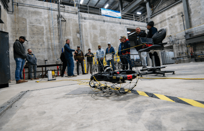

Engineers demonstrate the enhanced Elios3 drone, showcasing its tethered power configuration and real-time light detection and ranging data visualization during testing at an Idaho National Laboratory Site facility.
IDAHO FALLS, Idaho — The Idaho Cleanup Project (ICP) is preparing for new drone missions to collect detailed 3D images and radiation measurements in two high-level radioactive waste storage areas to help engineers verify conditions and guide placement of equipment to safely retrieve calcine, a byproduct of used nuclear fuel recycling, for disposition outside Idaho.
The granular byproduct is stored in six concrete bin sets resembling silos at the Idaho National Laboratory Site. Under the 1995 Idaho Settlement Agreement, the U.S. Department of Energy must retrieve, package and remove the 4,400 cubic meters of calcine from Idaho by 2035.
The ICP’s Calcine Disposition Project is drawing from advanced technology to expand on the success of its historic 2022 drone flight — the first known operation inside a high-level radioactive waste storage vault.
“Some of the biggest risks and schedule impacts to a project are the unknowns,” said Valerie Kimbro, senior project manager. “The extended flight capabilities of the drone and updated 3D imaging technology reduce these unknowns, helping the project move forward while meeting regulatory commitments.”
In December, team members tested an upgraded Elios3 drone at an onsite test facility that includes a full-scale mock-up of a storage bin set. Enhancements include an optional tethered power source, larger battery packs and an updated system for the light detection and ranging technology. It features a scan rate that’s 25 times faster than previous versions, improving the resolution of data collected. It allows for more detailed imagery in the same amount of scanning time and enables detection of smaller details difficult to identify with earlier equipment.
“The extended flight capabilities and updated light detection and ranging technology ensure needed data can be collected with subcentimeter accuracy, reducing overall project risks and keeping workers safe,” said Kimbro.
The test flights evaluated the drone’s ability to navigate around obstacles while tethered, measure flight durations and manage cables. These upgrades will allow for longer missions and more efficient data collection.
The Calcine Disposition Project has also implemented other innovations, such as a recently installed instrument control system at the test facility. These tools complement the drone’s capabilities, ensuring safe and efficient progress toward calcine retrieval.
-Contributors: Ryan Christensen, Leslie Dal Lago
To receive the latest news and updates about the Office of Environmental Management, submit your e-mail address.