
Welcome to the Colorado Plateau!
The Colorado Plateau is a beautifully sculpted range of natural wonders. It is centered on the Four Corners region of the southwestern United States. The Four Corners region is made up of the corners of four states — western Colorado, northwestern New Mexico, southeastern Utah, and northern Arizona.
This high-desert area was formed millions of years ago when tectonic plates beneath the earth’s surface slowly pushed together, uplifting stacked layers of sand, silt, and mud to form the Colorado Plateau. These exposed layers were cut through by wind, rivers, and streams to form winding, high-walled canyons and mesas. This stunning and rugged landscape has been home to American Indians and their ancestors for thousands of years.
The strength and resilience that it takes to live in the arid climate and high elevation of the Colorado Plateau are evident in the rare but hearty desert plants that grow here and the ancient and present-day animals that roam this awe-inspiring area of the United States.
The Colorado Plateau is rich with recreational opportunities like hiking, biking, climbing, rafting, camping, and sightseeing. It is also rich in minerals, which are found in rocks and are made up of different elements. One element found in the minerals of the Colorado Plateau was highly sought after during World War II and the Cold War — uranium.
COLORADO PLATEAU INTERACTIVE SITE MAP
LM is the caretakers of legacy sites that played a critical role in America’s nuclear history. Today, The U.S. Department of Energy Office of Legacy Management (LM) looks after more than 20 sites on the Colorado Plateau that processed uranium during World War II and the Cold War.
Click on the links below to learn more about LM’s sites on the Colorado Plateau.
The Colorado Plateau gets its name from the Colorado River. About 90 percent of the area is drained by the Colorado River and its main tributaries: the Green, San Juan, and Little Colorado Rivers. The Colorado River and its tributaries flow not only through the state of Colorado but also through the states of New Mexico, Utah, and Arizona. In fact, only 12 percent of the Colorado Plateau is in the state of Colorado!
The Colorado Plateau is home to a variety of unique plants and animals, including some that are not found anywhere else in the world. It provides distinct habitats for plants and animals to live in.
WOODLAND ZONE
The woodland zone, or pinyon-juniper woodland, covers a large area of the Colorado Plateau. It consists of open woodlands of short trees, mostly pinyon pine and Utah juniper. The ground is covered by sparse grasses, herbs, and shrubs, such as big sagebrush and alder-leaf mountain mahogany.
Photo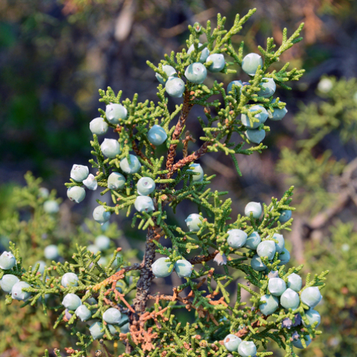 CaptionUtah juniper leaves and berries.Photo
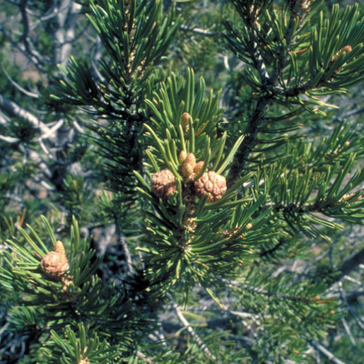 CaptionTwo-needle pinyon pines can grow up to 20 feet tall and 20 feet wide when they are mature; they are called “two-needle” pinyon pine because two needles (leaves) are attached at each point on the stem. Compare this tree to Ponderosa pines and lodgepole pines in the Mountain Zone.Photo
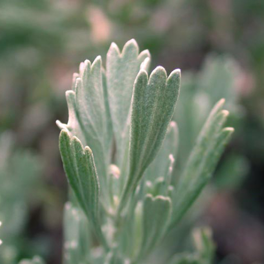 CaptionBig sagebrush can be identified by its leaves: each leaf has three lobes at its end. Native Americans have used sagebrush for thousands of years for medicine, ceremonies, fiber, and dye.Photo
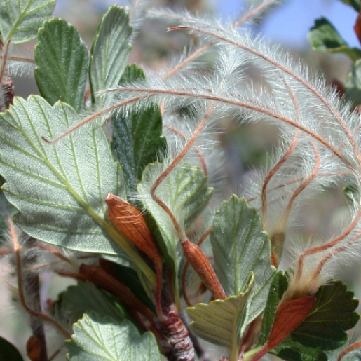 CaptionAlderleaf mountain mahogany; this 4- to 8-foot-tall shrub has seeds containing a hairy “tail.”Photo
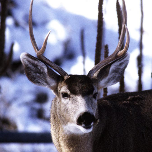 CaptionMule deer are commonly found in the Colorado Plateau’s Woodland Zone. How do you think they got their name? (Hint: Are those big ears or what?!)Photo
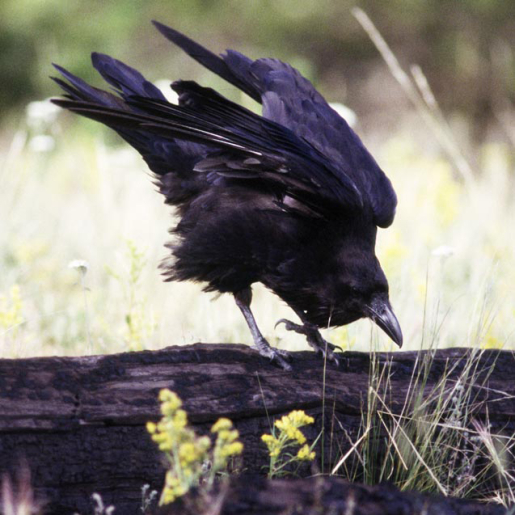 CaptionCommon ravens are omnivores, which means they will eat anything available: roadkill, insects, eggs, seeds, berries, and even dung. These smart birds are known to store extra food away in secret hiding places for later. If a raven senses that another raven is watching where it is about to hide food, it will pretend to stash the food in one place, but will actually hide it in a different spot. Another fun fact: a group of ravens is called a “murder.”PhotoCaptionUtah juniper leaves and berries.
Utah juniper leaves and berries.
ARID GRASSLANDS AND SAGEBRUSH-STEPPE
Arid grasslands and sagebrush-steppe occupy lowland and mid-elevation areas. Grasses, sagebrush, desert shrubs, cacti, and yucca dominate the area, and because of low humidity, areas of bare soil are common.
Photo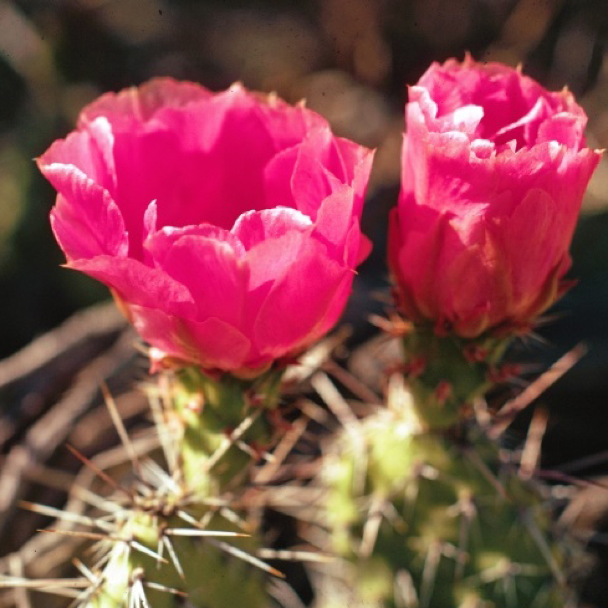 CaptionPlains pricklypear cactus are common throughout the western U.S.; their blooms can vary from pink to yellow. The plant gets its name from the numerous sharp spines on its stems. The reddish-colored fruit it bears is known as a pear or tuna.Photo
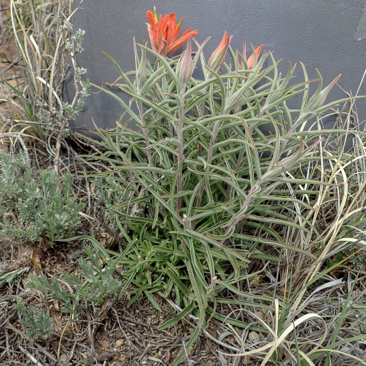 CaptionIndian paintbrush in the sagebrush-steppe; the orange, flower-like tops of the plant are actually leaves.Photo
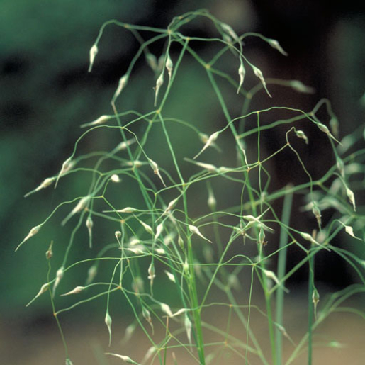 CaptionNative Americans ground the seeds of Indian ricegrass, a common bunchgrass in the sagebrush-steppe zone, to make bread and porridges.Photo
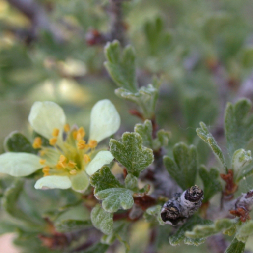 CaptionThe flowers of antelope bitterbrush (a common shrub in the sagebrush-steppe) have five petals, and the leaves have three lobes (compare to the leaves of big sagebrush!) (Hint: the leaves of antelope bitterbrush are wider and shorter than those of big sagebrush; they are also less “blue”; both are somewhat “furry.”)Photo
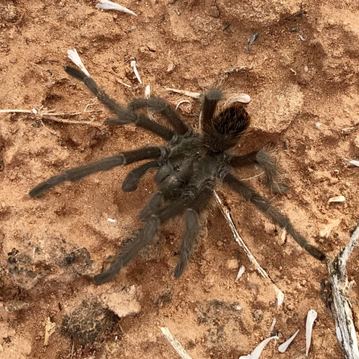 CaptionMale tarantulas migrate across the Colorado Plateau in September and October. Why do they migrate? Like males of most species, they are looking for a mate!Photo
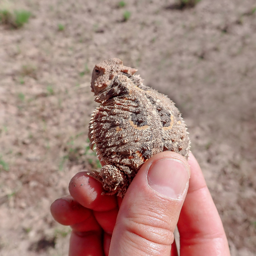 CaptionHorny toads (or horned lizards) are common reptiles in desert areas on the Colorado Plateau. Their coloring and skin texture help camouflage them on the ground.Photo
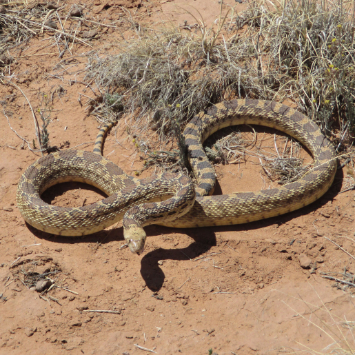 CaptionA bull snake at one of DOE’s Colorado Plateau sites; note that there’s no rattle on its tail.Photo
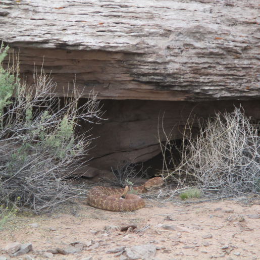 CaptionA diamondback rattlesnake (note the rattle on the end of its tail).Photo
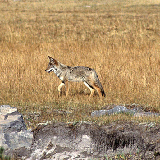 CaptionCoyotes normally hunt alone or in pairs, and they eat almost anything!Photo
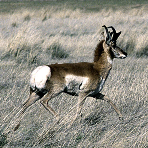 CaptionA young pronghorn trots across a grassland. Pronghorns are the second fastest animal on the land (cheetah is the fastest); they can achieve speeds of 53 miles per hour and run a mile and a half without slowing down. Coyotes, bobcats, and wolves are their main predators.PhotoCaptionPlains pricklypear cactus are common throughout the western U.S.; their blooms can vary from pink to yellow. The plant gets its name from the numerous sharp spines on its stems. The reddish-colored fruit it bears is known as a pear or tuna.
Plains pricklypear cactus are common throughout the western U.S.; their blooms can vary from pink to yellow. The plant gets its name from the numerous sharp spines on its stems. The reddish-colored fruit it bears is known as a pear or tuna.
MOUNTAIN ZONE
The mountain zone includes high plateaus and mountains. It is made up of woodlands and forests, chiefly ponderosa pine in the south and lodgepole pine and quaking aspen to the north.
Numerous animals have adapted to the hot summers and cold winters on the Colorado Plateau. Typically shy around humans, they are not as easy to see as plants, but signs of their presence (tracks, scat, or calls) can often be seen or heard by the close observer.
Photo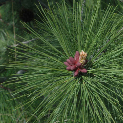 CaptionPonderosa pines are tall evergreen trees that have three long needles (leaves) attached together at each point on the stem. Compare these trees to two-needle pinyon pines in the Woodland Zone, which have two needles attached at each point.Photo
 CaptionLodgepole pine trees can grow up to 150 feet tall and live up to 400 years. They are called “lodgepole” because Native Americans used the straight and slender poles of the trees to support their lodges. Like two-needle pinyon pine trees in the Woodland Zone, these trees have two needles attached together at each point on the stem. Can you tell the difference between the two trees? (Hint: pinyon pines are relatively short and wide; lodgepole pines are relatively tall and slender)Photo
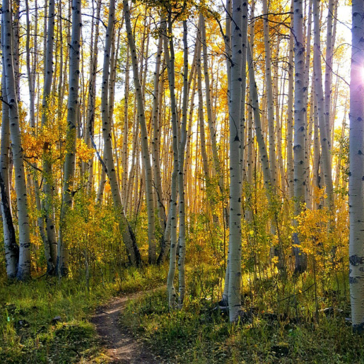 CaptionAspens can be identified by their smooth, white bark. A grove of quaking aspens in Utah is the largest known living thing on earth. Nearly 50,000 stems protrude from a single root system, and the entire organism covers over 100 acres.Photo
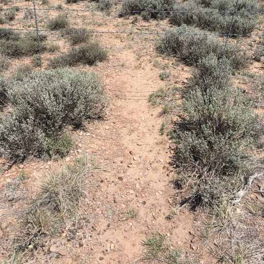 CaptionWildlife path with scat and tracks at the Gunnison site.Photo
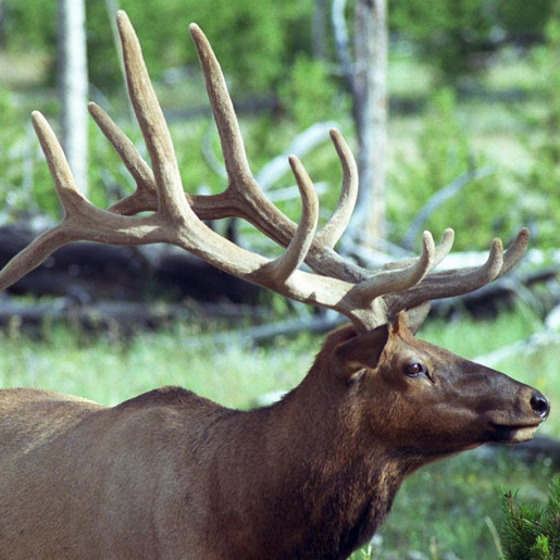 CaptionWeighing in at up to 700 pounds, the North American elk stands as one of the biggest deer species on earth. A mature bull (a male elk) can run as fast as 40 miles an hour and jump 8 feet vertically!Photo
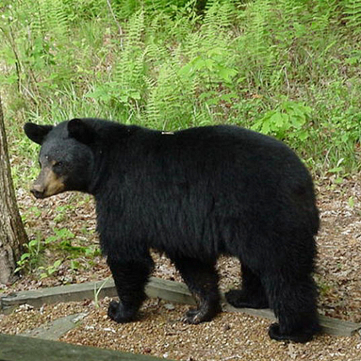 CaptionBlack bears are the smallest bears in North America and are the only bears living on the Colorado Plateau. Did you know that black bears can have coats that are blonde, cinnamon, or brown?PhotoCaptionPonderosa pines are tall evergreen trees that have three long needles (leaves) attached together at each point on the stem. Compare these trees to two-needle pinyon pines in the Woodland Zone, which have two needles attached at each point.
Ponderosa pines are tall evergreen trees that have three long needles (leaves) attached together at each point on the stem. Compare these trees to two-needle pinyon pines in the Woodland Zone, which have two needles attached at each point.
Uranium is contained in various minerals. One mineral that contains the element uranium is called “carnotite.” Carnotite also contains the elements radium and vanadium. Carnotite is found in a geologic formation known as the Morrison Formation. The Morrison Formation also contains dinosaur fossils!
Areas in the Colorado Plateau that are particularly rich in minerals containing uranium ore are known as “mineral belts.” Two mineral belts in the Colorado Plateau that contain large amounts of uranium ore are the Raven Mineral Belt in Colorado and the Grants Mineral Belt in New Mexico. “Ores” are rocks that are valuable because of the elements and minerals that they contain. Miners mine ore.
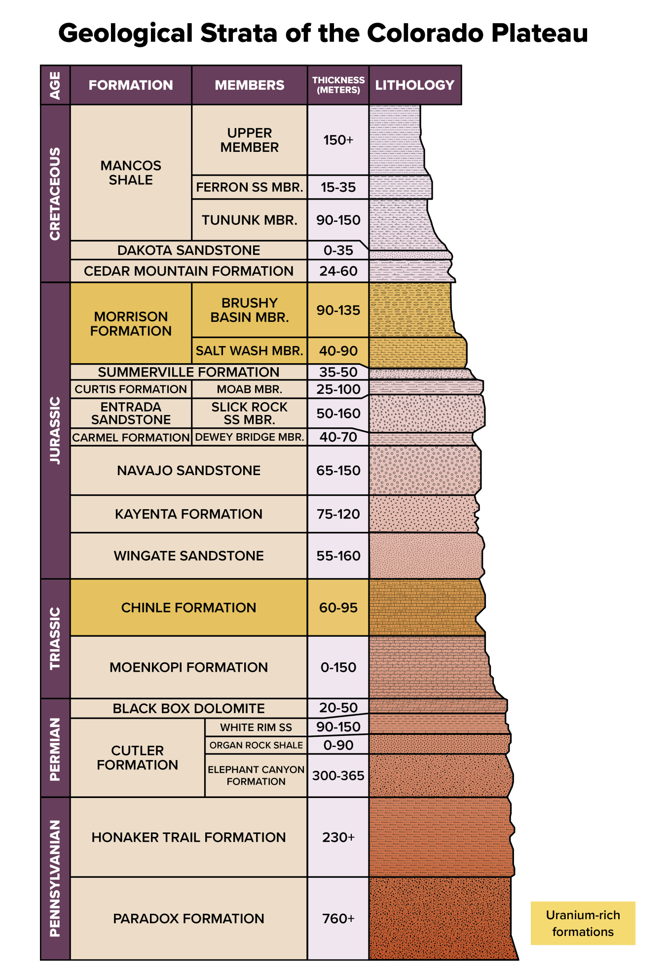
The Colorado Plateau is made up of numerous layers — or strata — of sedimentary rock. As you explore the Colorado Plateau, you can often see the different layers of rocks, because over the course of millions of years, rivers have cut through them and exposed them to view. Uranium ore is found in certain tan-colored sandstone layers.
The Colorado Plateau played an important role in national defense during World War II. Vanadium ore was mined to strengthen steel for warships and tanks. Uranium was extracted from Vanadium mill tailings to use in nuclear weapons. Making nuclear weapons was a top-secret project, known as the Manhattan Project. About 14 percent of the uranium used by the Manhattan Project came from the Colorado Plateau.
After World War II, the United States and the Soviet Union raced against each other to build nuclear weapons. Because the United States and the Soviet Union never actually fought a war against each other, the decades between World War II and 1991 are known as the “Cold War.” The race to build nuclear weapons during the Cold War required large amounts of uranium.
At the beginning of the Cold War, the U.S. Atomic Energy Commission (AEC) took on the responsibility for making nuclear weapons. In 1948, AEC guaranteed to purchase uranium ore at a good price, which meant people could get rich if they could find enough uranium. A stampede of prospectors flooded into the Colorado Plateau. It was like a gold rush, but instead of gold, people rushed to the Colorado Plateau to find uranium.
By the mid-1950s, there were 800 major uranium producers on the Colorado Plateau, and ore production doubled every 18 months. From 1949 to 1971, uranium mines produced 400 million tons of ore.
LM not only maintains the sites in its custody but strives to use the legacy sites in beneficial ways that are consistent with its mission to optimize use of public lands and to protect human health and the environment. This is called beneficial reuse.
How each site is reused may result in a wide variety of activities, such as transferring land to a third party, developing on-site educational resources, restoring natural habitats, or engaging in agricultural activities. LM’s Beneficial Reuse Program thoroughly assesses a site’s potential by considering environmental, social, and economic benefits to LM and local communities. LM revitalizes legacy sites by replanting vegetation, creating and encouraging ecosystems, and enhancing habitat areas for threatened or endangered species. These activities can lead to recreational tourism, which benefits neighboring communities through job creation and increased revenue.

Reuse opportunities are assessed at the time a site transitions to LM and are periodically reassessed as long-term stewardship and maintenance of the site progresses. LM will continue to partner with other agencies and organizations at legacy sites to contribute to national, and regional goals. Presently, LM is in the process of reevaluating its sites — including those transitioning in the next five years — to determine whether additional opportunities for reuse exist.
Learn more: https://www.energy.gov/lm/services/property-management/beneficial-reuse
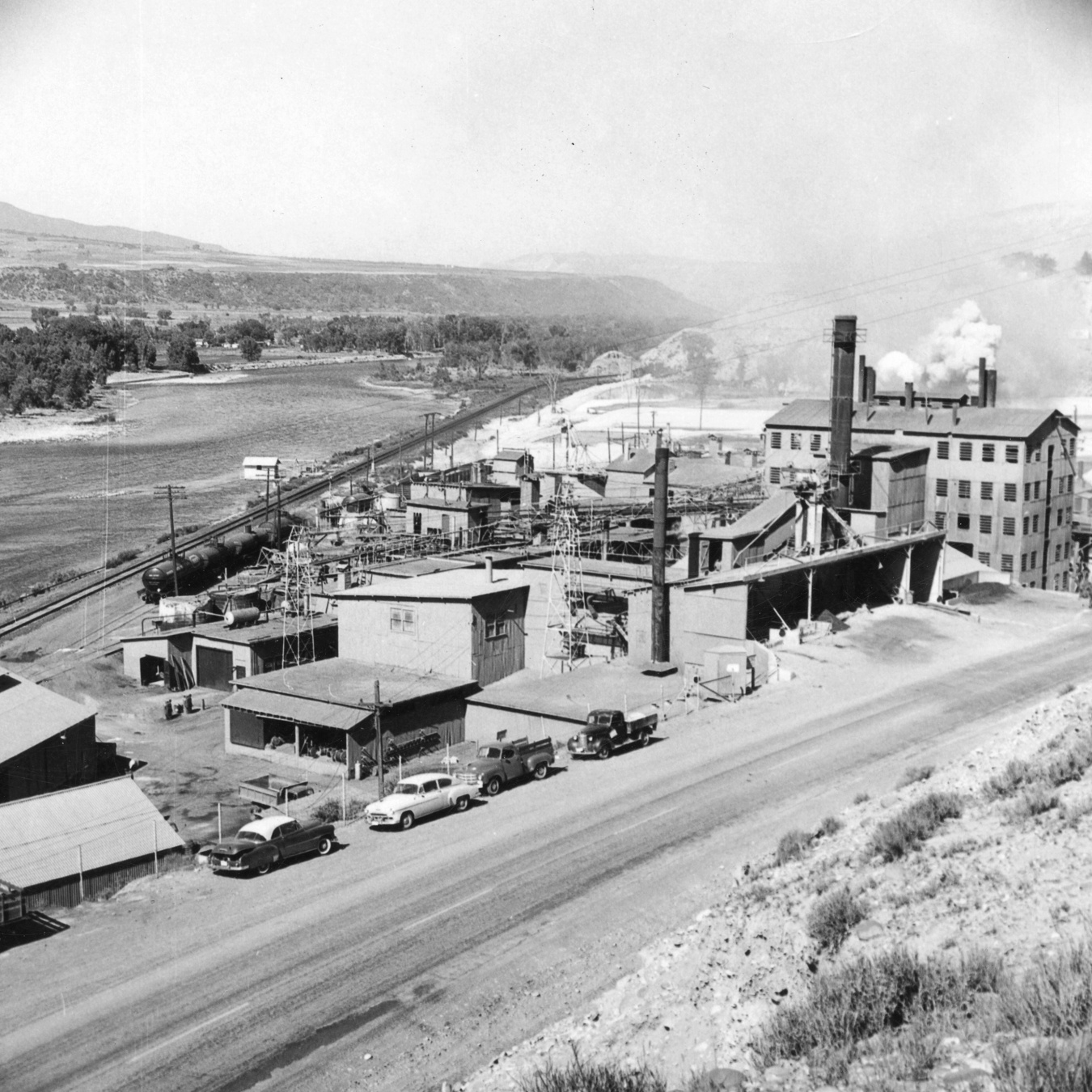
Old Rifle mill site in operation.
Once mineral-rich ore is extracted from the earth, it must be milled to pull out uranium and other elements such as vanadium, molybdenum, and selenium. At a conventional mill, rock is crushed into smaller particles, then put through a leaching process that uses chemicals to separate the uranium from the rest of the ore.
The uranium milling process creates a byproduct known as mill tailings. Mill tailings are a fine, sandy material left over from the milling process. Uranium mill tailings contain small amounts of radium, a product created from the radioactive decay of uranium atoms. As radium decays, it releases a gas called radon. Radon gas is radioactive and can be harmful to humans and the environment.
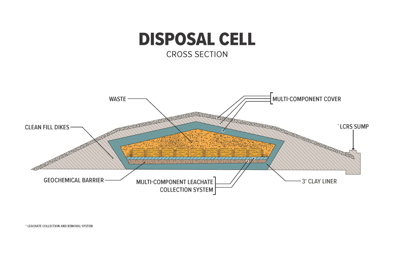
Containing uranium mill tailings inside a disposal cell is a way to keep humans and the environment protected from radon gas and radioactive material.
Construction varies but cells often include disposed waste and a clean-fill dike made of compacted clay soils. An engineered cover serves as armor to contain the waste inside the cell. It consists of multiple layers including an infiltration/radon barrier of clay, a geosynthetic liner, a gravel drain, sand filter, and a rock cap. Some cells may also have a natural, vegetative cover.