
The Environmental Management Nevada Program is implementing technology that will aid data collection and reduce environmental impacts at groundwater wells at the Nevada National Security Site.
Office of Environmental Management
January 7, 2025LAS VEGAS — The Environmental Management (EM) Nevada Program is implementing technology that will aid data collection and reduce environmental impacts at groundwater wells at the Nevada National Security Site (NNSS).
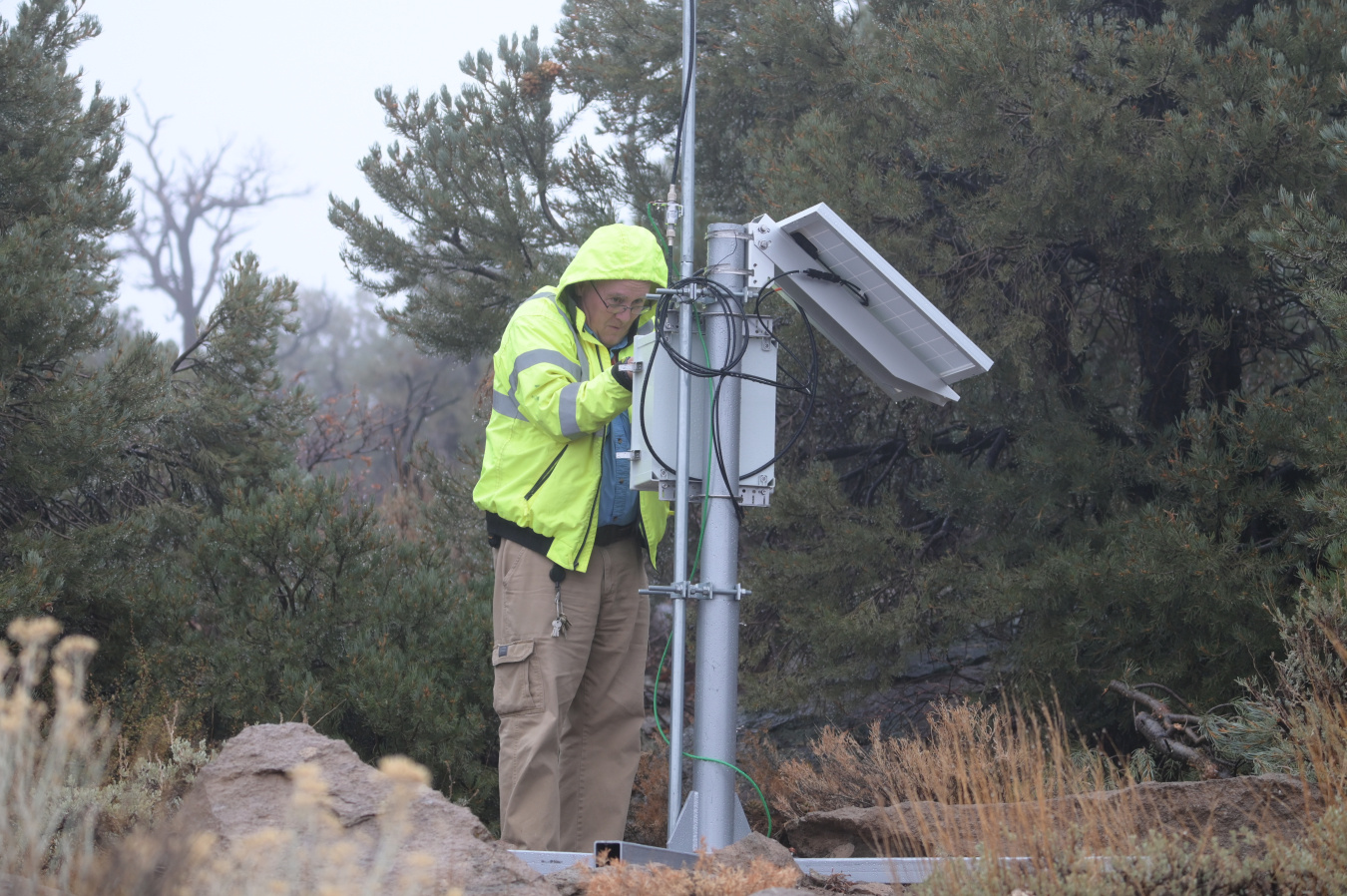
Underground Test Area Chief Geologist Chris Lewis inspects Innovative Wireless Technologies equipment at the Rainier Mesa groundwater corrective action unit on the Nevada National Security Site.
Innovative Wireless Technologies (IWT) equipment has been added to 16 groundwater monitoring locations on the NNSS and the nearby Nevada Test and Training Range (NTTR). Together these wells will create the Automated Telemetry Data Collection Long-Term Water Level Monitoring system network.
The equipment works by sending data via radio waves; information is transferred from wells via the network and uploaded to a secure server. The data is recorded daily and can be accessed offsite, even from the building in Las Vegas where EM Nevada has its offices.
“The idea behind it is instead of having to physically go to the site and hook up the computer and download the data, we are setting up technology where that information is automatically transmitted,” said Ken Rehfeldt, Underground Test Area (UGTA) manager.
A closer look at an Innovative Wireless Technologies-equipped well head, node and solar panel.
The technology can transmit any kind of data, but the network locations are being used to measure, collect and transmit groundwater levels. This is important for scientists in part to understand if there are changes in groundwater movement or behavior. It also helps to inform flow models and projections.
Previously, UGTA crew members would collect data from monitoring wells about every three months. While this will remain the case at selected locations, the network will offer time, energy and cost savings at the locations it is used. Many of these wells, particularly on the NTTR, are positioned in remote areas and take time to reach. The automated process will save crew members lengthy trips and provide quicker access to critical data.
The technology will also allow the UGTA team to be more efficient with the trips they choose to take. In the past if there was a malfunction with equipment, scientists were unaware until they made their quarterly visits. With the equipment uploading information daily, UGTA will learn almost immediately if there is an issue with data collection.
“We’ll be able to limit the amount of data loss and it saves us vehicle trips. So it’s better for the environment, fewer miles on the vehicle and less staff time,” Rehfeldt said. “Instead of having to go to these locations every three months, we expect to make fewer trips per year and only as the need arises.”
EM Nevada implemented a pilot version of the technology at four wells early in the summer and expanded to 12 additional wells in late September. The data transmitted to the server is encrypted to ensure security. Each physical IWT node has a memory card, which backs up the data and allows it to be collected manually, if needed. Each location also has a solar-powered charger and extra heavy-duty batteries, all protected in an all-weather enclosure.
The installation of the network at the NNSS was supported by DOE’s Climate Action Plan. The federal effort is aimed at furthering climate mitigation efforts at DOE sites. The UGTA team conducted months of research on the technology and submitted a detailed proposal to DOE leadership. EM Nevada received $700,000 in fiscal year 2022 to support the installation.
Since DOE’s launch of the NNSS groundwater investigation program in 1989, three of four groundwater corrective action areas have been brought to regulatory closure under the Federal Facility Agreement and Consent Order. Pahute Mesa, the final remaining groundwater region at the site, advanced to the “model evaluation” phase in 2023, a major step toward achieving closure. The phase calls for additional drilling, water level measurements and sampling to compare field data to groundwater model projections.
Seven of the network wells are positioned on Pahute Mesa and will help support model evaluation. The other locations will support long term monitoring elsewhere on the site and NTTR. Regular measurement of groundwater levels is part of the long term monitoring requirements agreed upon between DOE and the State of Nevada.
“It’s a little bit of both,” Rehfeldt said of the technology usage. “Right now we’re implementing it and using it for long term monitoring, but we’re also going to use the technology for model evaluation.”
Crews will go to the network wells a minimum of once a year. All data collected will also be sent to the U.S. Geological Survey.
Click here for more about the NNSS groundwater program.
-Contributor: Grant Johnson
To receive the latest news and updates about the Office of Environmental Management, submit your e-mail address.