
The LM DRUM program is a partnership between DOE, federal land management agencies, and state and tribal abandoned mine lands (AML) programs.
February 11, 2021DRUM Program Overview
The U.S. Department of Energy (DOE) Office of Legacy Management (LM) Defense-Related Uranium Mines (DRUM) program is a partnership between DOE, federal land management agencies, and state and tribal abandoned mine lands (AML) programs to verify and validate the condition of approximately 4,225 mine sites across the nation. DRUM sites provided uranium to the U.S. Atomic Energy Commission (AEC) for defense-related activities that occurred between the years 1947 and 1970.
A 2014 DRUM report to Congress made obvious the lack of knowledge of current conditions at these mines. The DRUM Program fills in that knowledge gap, identifying risks to human health and the environment posed by abandoned uranium mines.
Most DRUM sites are located on easily accessible public land and were abandoned prior to reclamation mining laws. Initiated in 2017, DRUM Campaign 1 focuses on approximately 2,500 legacy mines located on public land administered by federal and state agencies. LM implements the program by conducting verification and validation (V&V) activities, resulting in useful information for both LM and its partners.
The initial implementation of the V&V process occurred on land managed by the U.S. Bureau of Land Management (BLM) Uncompahgre Field Office (UFO). Through close collaboration with UFO, the DRUM Program continues to improve.
The general V&V process includes:
- Exchanging mine-related information with other federal, state, and tribal governments to determine mines of interest.
- Performing field inventories to document mining-related features at DRUM sites for safety risks.
- Conducting environmental sampling to evaluate human health and environmental risks.
- Producing mine-specific reports that document conditions at DRUM sites.
- Working with partner agencies to leverage resources to address mines with priority physical safety hazards.
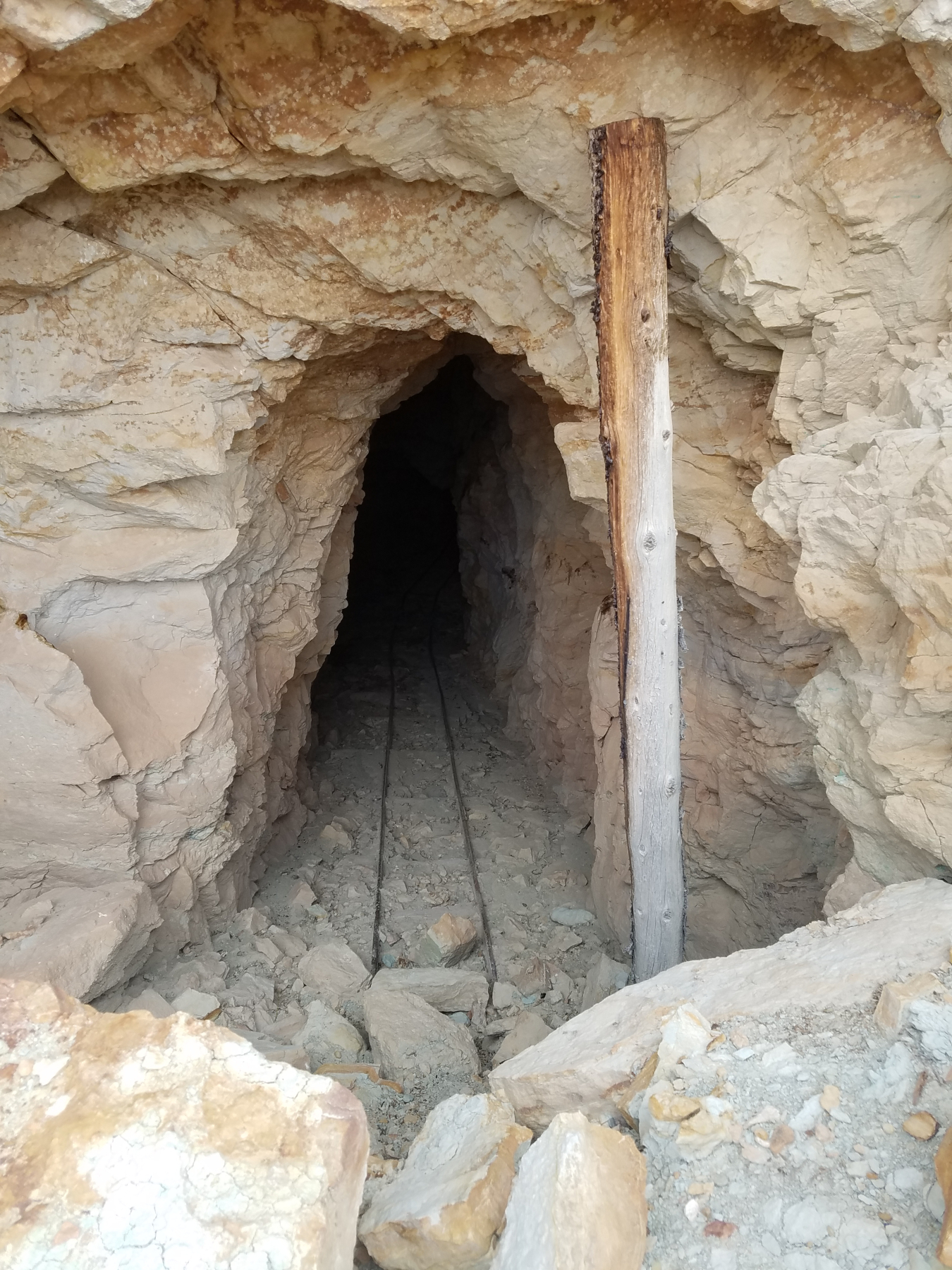
This unstable adit could entice dangerous exploration at the Yellow Bird 1 mine in Western Colorado.
Standing Up an Entire Program from Scratch
LM’s primary goal is protecting human health and the environment. Recognizing similar interests shared by other federal and state agencies, LM partnered with them to determine data objectives for gathering and sharing mine inventory and ranking of hazards. The program needed to be extremely adaptive to address and balance a variety of agency-specific concerns, adjust to unique circumstances, and accommodate internal processes of the various partners. Given this complexity, partner input was paramount and necessary to forge a process accepted by all the parties. This was a critical step before the characterization of abandoned uranium mine sites could begin.
In March 2017, LM began implementing the first DRUM V&V Work Plan and held a field meeting with UFO. This team effort further forged the partnership, improved program execution, and advanced data collection and reporting methods.
In April 2019, during a meeting between LM Director Carmelo Melendez and UFO Field Office Manager Greg Larson, it became apparent the DRUM Program’s goals needed to expand to include the safeguarding of physically hazardous features identified by the V&V work, such as adits, shafts, and trenches. Larson expressed concerns that “by only conducting V&V, the DRUM Program was serving all the problems associated with their AML inventory to the land manager on a silver platter” and he requested assistance in addressing identified hazards. In response, LM added safeguarding to the DRUM Program in July 2019.
Uncompahgre Field Office Mission
BLM’s AML Program addresses physical safety and environmental hazards associated with mines on BLM-administered public lands that were abandoned prior to Jan. 1, 1981. Over the last 150 years, much of the land managed by BLM has experienced some form of mining activity, ranging from exploration to mineral production.
UFO prioritizes and takes appropriate action on legacy abandoned mine sites — an enormous task, requiring time, funding, and collaboration with other federal, state, and local governments. BLM has decades of hazard mitigation experience and shared data sets, road access, mining terminology, and other vital information with the DRUM Program.
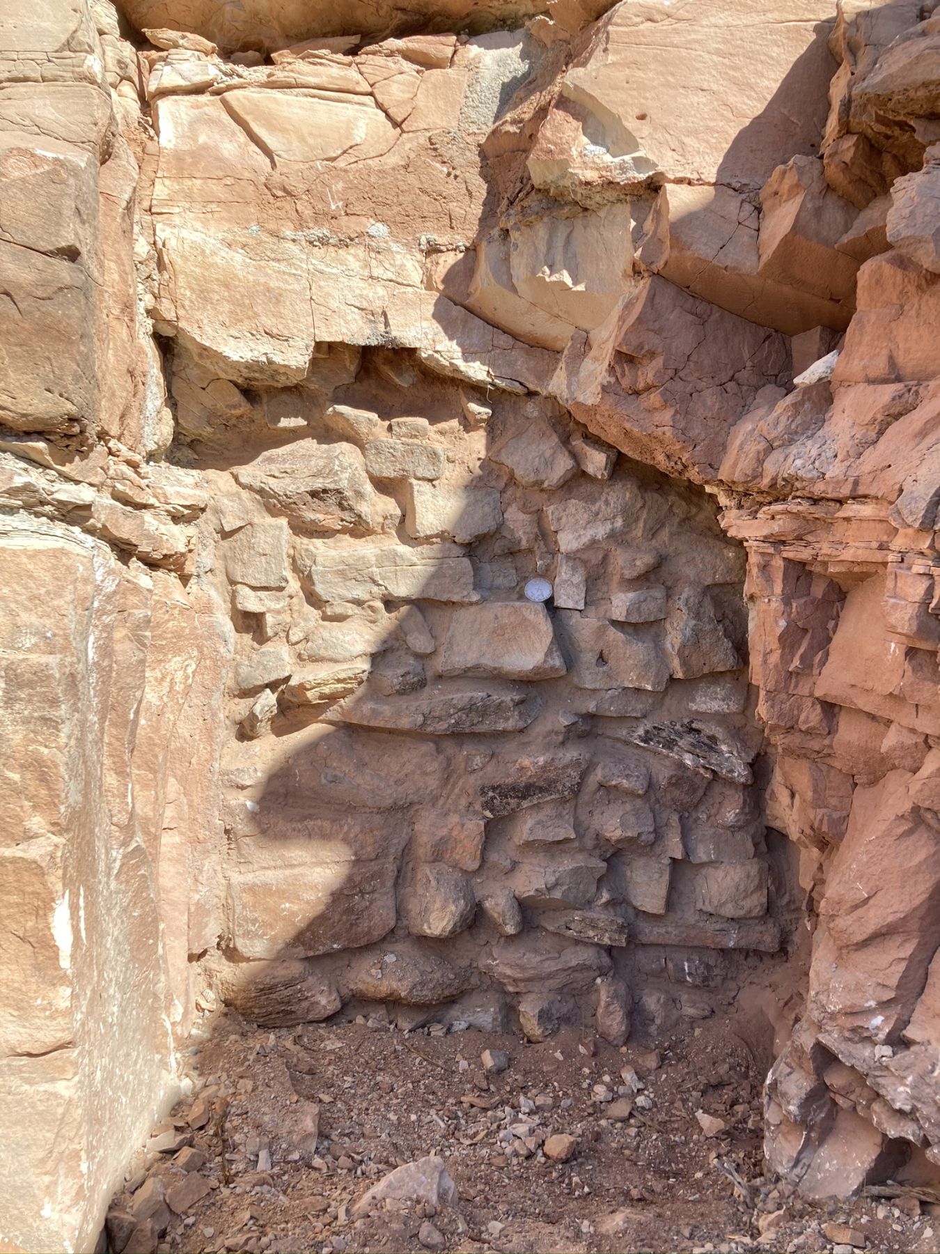
An Audit entrance secured using natural stone during the 2020 Long Park safeguard project in Colorado.
Development of the DRUM Program with the UFO
The DRUM Team tracked down a wide array of sources to gain an understanding of historic uranium mining. For instance, a “shoebox” of production records shared by former AEC Geologist William Chenoweth proved to be a windfall of information. DRUM used Chenoweth’s records to identify mining activity that had been incentivized by AEC and, thereby, defense-related. The production records also included township, range, and section information, providing the first steps in the V&V process.
Starting in the UFO area, BLM and the Colorado Department of Reclamation, Mining and Safety (DRMS) supported DOE with additional data sets, which led to locating 144 mines in the Uravan mining district. This “hit list” of mines formed the UFO Field Operations Plan, which recorded and conveyed to all relevant parties any limitations or restrictions present in the area.
In 2017, the DRUM Program initiated field activities in mining districts near LM’s Grand Junction, Colorado, office to facilitate the refinement of program processes and procedures through in-field observations and collaboration with UFO and the AML community. This crucial phase cultivated data-collection methods that not only characterized what physical, environmental, and radiological hazards were present at each site but also placed the data in a geographic information systems (GIS) format, allowing mine-specific reports to be produced in a timely and cost-effective manner. Each data objective was matched with collection and recordation methods to achieve the shared program goals of LM and UFO.
Key reviews of environmental sampling processes and feature characteristics were performed during the initial phase of the program. Consulting with UFO staff and BLM technical experts, various forms of equipment were tested, such as ruggedized tablets, geophysical instruments, soil and water sampling tools, off-highway vehicles, and trailers. This provided a robust field team model and ensured that a pertinent data collection strategy towards recognizing and safeguarding hazards. When previous physical hazard safeguards were observed at a mine site, field teams also noted their integrity, as well as whether they were still effective or if maintenance was required.
After identifying and collecting the various data inputs needed to screen each mine for physical hazards and potential risks to human health, information was then collated into individual V&V reports. The DRUM Team discussed screening and reporting methods with UFO and other federal and state experts. These reports include historical data, feature information, photographs, environmental data, and a risk-screening assessment (RSA).
RSAs include evaluation criteria not only for physical hazards and potential human health risks but also modifying factors, such as the degree of public access to a mine, cumulative risk ratios, complexity criteria, and an ecological and environmental hazard evaluation. RSAs serve as a “snapshot in time” for mining characteristics during a field visit. The process assumes a recreational use scenario of 14 days per year for 26 years, adopted from BLM policies, and it includes decision point screening levels for gamma radiation, heavy metals in soil, and radium-226 exposure.
During one of many field outings with UFO, a hazardous mining subsidence was identified near a popular four-wheel-drive road. Posing a higher than normal risk to the public, it was decided that a special category be made to prioritize mining-related hazards that could pose a significant and immediate threat to a visitor. These “notifiable features” include subsidence areas, shafts, explosives, chemical containers such as transformers with PCBs, and severely compromised structures, located adjacent to well-travelled public roads. When field teams identified notifiable features, they provided the location description of the hazard to UFO.
Mine-specific reports are generated for each DRUM site. However, to better collaborate with partner agencies, the DRUM Team agreed to provide land management agencies with risk rollup reports. The reports provide a dashboard summary and side-by-side comparison of all DRUM sites in a geographic area. The reports assign risk to adjacent mines in a specific geographic area, helping land management agencies to prioritize and establish concurrence for future safeguarding projects. With the intent to provide enough information to make risk-informed decisions about potential follow-up actions, the reports use two sets of benchmarks based on physical hazards and potential long-term exposure. While LM does not have the authority to participate in response actions to DRUM sites under the Comprehensive Environmental Response, Compensation, and Liability Act (CERCLA), the DRUM Team assists partner agencies by providing data and ranking information about human health risks posed by long-term exposure to chemical or radiological constituents at mines.
In 2019, LM and UFO staff walked the mine sites in Long Park using the mine-specific V&V and risk rollup reports. They ensured the mine conditions had not changed since the report date, came to an agreement on the hazards to be addressed, and discussed what else might be done during the mobilization that might not be “technically” classified as a hazard, such as backfilling a shallow trench. This was an important step in the concurrence process and served as the basis for project development.
In preparing project documents, UFO required the associated electronic data from LM. The sharing of large quantities of electronic data and content (e.g., GIS, reports, photographs) with partner agencies required the use of a compatible electronic file transfer site. Data packages were distributed to UFO and other parties involved with future safeguarding projects.
In 2020, LM expanded its commitment to assisting partner agencies by developing an administrative categorical exclusion (CXE), which allows LM to efficiently comply with responsibilities outlined by the National Environmental Policy Act (NEPA) when LM funds are used for safeguarding projects. The CXE describes the acceptance of the NEPA decision of the federal land manager. With this decision document in place, LM was able to provide funding and implement all the requisite studies for its first safeguarding project in UFO’s Long Park area in fall 2020. The project involved the safeguarding of 26 hazardous features in cooperation with UFO, DRMS, and Bat Conservation International.
Conclusion
The DRUM Program has seen numerous changes in program development throughout the years, and its many successes are rooted in the assistance provided by UFO and BLM. The collaborative spirit shared by DRUM partners illustrates the program’s adaptability to new directives and priorities. Land management agencies have finite resources to meet their AML obligations. LM aims to fill any gaps where its mission overlaps. The DRUM Program has progressed exponentially, thanks to the continual involvement, collaboration, and communication with BLM national, state, and field offices. Together BLM and LM have advanced the protection of human health and the environment at DRUM sites — a true symbol of the “One Team, One Mission” ethos.