
To build a micro-hydropower system, you need access to flowing water on your property. A sufficient quantity of falling water must be available, which usually, but not always, means that hilly or mountainous sites are best. Other considerations for a potential micro-hydropower site include its power output, economics, permits, and water rights.
To see if a micro-hydropower system would work for you, you will want to determine the amount of power that you can obtain from the flowing water on your site. This involves determining these two things:
- Head -- the vertical distance the water falls
- Flow -- the quantity of water falling.
Once you've determined the head and flow, then you can use a simple equation to estimate the power output for a system with 50% to 70% efficiency or more, which is representative of most micro-hydropower systems.
Simply multiply net head (the vertical distance available after subtracting losses such as pipe friction - the losses will depend on the type size of the pipe among other things, but can be estimated to be from 5 to 10 percent for preliminary calculations) by flow (use U.S. gallons per minute) divided by 10. That will give you the system's output in watts (W). The equation looks this:
[net head (feet) × flow (gpm)] ÷ 10 = W (Power or Watts)
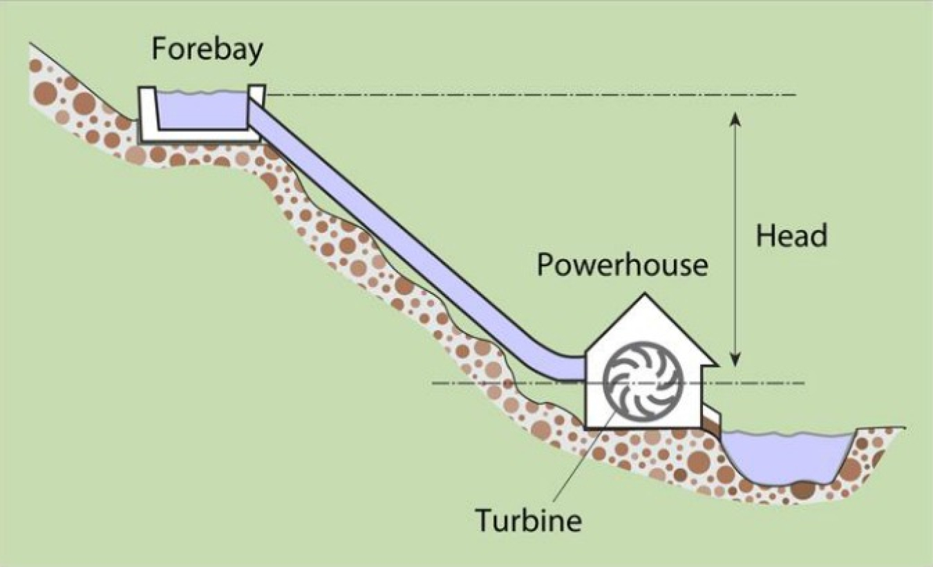
Determining the “Head” at Your Potential Microhydropower Site
In a potential microhydropower site, head is the vertical distance that water falls. When evaluating a potential site, head is usually measured in feet, meters, or units of pressure. Head also is a function of the characteristics of the channel or pipe through which it flows.
Most microhydropower sites are categorized as low or high head. The higher the head the better because you'll need less water to produce a given amount of power and you can use smaller, less expensive equipment. Low head refers to a change in elevation of less than 66 feet (20 meters), and ultralow head refers to a change in elevation of less than 10 feet (3 meters). A vertical drop of less than 2 feet (0.6 meters) will probably make a small-scale hydroelectric system unfeasible.
However, for extremely small power generation amounts, a flowing stream with as little as 13 inches of water can support a submersible turbine. This type of turbine was originally used to power scientific instruments towed behind oil exploration ships, and are similar to some hydrokinetic power systems from river or tidal currents.
When determining head, you need to consider both gross head and net head.
- Gross head is the vertical distance between the top of the forebay water level where the penstock (or pipe) that conveys the water under pressure is attached and the level of water where the turbine water discharges.
- Net head equals gross head minus losses due to friction and turbulence in the piping.
The most accurate way to determine gross head is to have a professional survey the site. To get a rough estimate, you can use U.S. Geological Survey maps of your area or the hose-tube method.
The hose-tube method for determining head involves taking stream-depth measurements across the width of the stream you intend to use for your system -- from the point at which you want to place the penstock to the point at which you want to place the turbine. You will need the following:
- An assistant
- A 20–30 foot (6–9 meters) length of small-diameter garden hose or other flexible tubing
- A funnel
- A yardstick or measuring tape.
- Stretch the hose or tubing down the stream channel from the point that is the most practical elevation for the penstock intake. Have your assistant hold the upstream end of the hose, with the funnel in it, underwater as near the surface as possible.
- Meanwhile, lift the downstream end until water stops flowing from it. Measure the vertical distance between your end of the tube and the surface of the water. This is the gross head for that section of stream.
- Have your assistant move to where you are and place the funnel at the same point where you took your measurement. Then walk downstream and repeat the procedure. Continue taking measurements until you reach the point where you plan to site the turbine.
The sum of these measurements will give you a rough approximation of the gross head for your site.
Note: due to the water's force into the upstream end of the hose, water may continue to move through the hose after both ends of the hose are actually level. You may wish to subtract an inch or two (2–5 centimeters) from each measurement to account for this. It is best to be conservative in these preliminary gross head measurements.
If your preliminary estimates look favorable, you will want to acquire more accurate measurements. As stated already, the most accurate way to determine head is to have a professional survey your site. But if you know you have an elevation drop on your site of several hundred feet, you can use an aircraft altimeter. You may be able to buy, borrow, or rent an altimeter from a small airport or flying club. A word of caution, however: while using an altimeter might be less expensive than hiring a professional surveyor, your measurement will be less accurate. In addition, you will have to account for the effects of barometric pressure and calibrate the altimeter as necessary.
Determining “Flow” at A Potential Microhydropower Site
The quantity of water falling from a potential micro-hydropower site is called flow. It's measured in gallons per minute, cubic feet per second, or liters per second.
The easiest way to determine your stream's flow is to obtain data from these local offices:
- The U.S. Geological Survey
- The U.S. Army Corps of Engineers
- The U.S. Department of Agriculture
- Your county's engineer
- Local water supply of flood control authorities.
If you can't obtain existing data, you'll need to conduct your own flow measurements. You can measure flow using the bucket or weighted-float method.
Bucket Method
The bucket method involves damming your stream with logs or boards to divert its flow into a bucket or container. The rate at which the container fills is the flow rate.
For example, a 5-gallon bucket that fills in 1 minute means that your stream's water is flowing at 5 gallons per minute.
Weighted-Float Method
Another way to measure flow involves measuring stream depths across the width of the stream and releasing a weighted-float upstream from your measurements. Due to water safety concerns, this method isn't recommended if the stream is fast-flowing and/or over your calves. You will need:
- An assistant
- A tape measure
- A yardstick or measuring rod
- A weighted-float, such as a plastic bottle filled halfway with water
- A stopwatch
- Some graph paper.
With this equipment you can calculate flow for a cross section of the streambed at its lowest water level.
- First, select a stretch of stream with the straightest channel, and the most uniform depth and width possible.
- At the narrowest point, measure the width of the stream.
- Then, holding the yardstick vertically, walk across the stream and measure the water depth at one-foot increments. To help with the process, stretch a string or rope upon which the increments are marked across the stream width.
- Plot the depths on graph paper to give yourself a cross-sectional profile of the stream.
- Determine the area of each section by calculating the areas of the rectangles (area = length × width) and right triangles (area = ½ base × height) in each section.
- Next, from the same point where you measured the stream's width, mark a point at least 20 feet upstream.
- Release the weighted-float in the middle of the stream and record the time it takes for the float to travel to your original point downstream. Don't let the float drag along the bottom of the streambed; if it does, use a smaller float.
- Divide the distance between the two points by the float time in seconds to get flow velocity in feet per second. The more times you repeat this procedure, the more accurate your flow velocity measurement will be.
- Multiply the average velocity by the cross-sectional area of the stream.
- Then multiply your result by a factor that accounts for the roughness of the stream channel (0.8 for a sandy streambed, 0.7 for a bed with small to medium sized stones, and 0.6 for a bed with many large stones). The result will give you the flow rate in cubic feet or meters per second.
Stream flows can be quite variable over a year, so the season during which you take flow measurements is important. Unless you're considering building a storage reservoir, you can use the lowest average flow of the year as the basis for your system's design. However, if you're legally restricted on the amount of water you can divert from your stream at certain times of the year, use the average flow during the period of the highest expected electricity demand.
Economics
If you determine from your estimated power output that a microhydropower system would be feasible, then you can determine whether it economically makes sense.
Since saving energy costs less than generating it, be sure your home is as energy efficient as possible, reducing your electricity usage so that you do not purchase a system that is bigger (and more costly) than you need.
Add up all the estimated costs of developing and maintaining the site over the expected life of your equipment, and divide the amount by the system's capacity in Watts. This will tell you how much the system will cost in dollars per Watt. Then you can compare that to the cost of utility-provided power or other alternative power sources.
Whatever the upfront costs, a hydroelectric system will typically last a long time and, in many cases, maintenance is not expensive. In addition, sometimes there are a variety of financial incentives available on the state, utility, and federal level for investments in renewable energy systems. They include income tax credits, property tax exemptions, state sales tax exemption, loan programs, and special grant programs, among others.
Permits and Water Rights
When deciding whether to install a micro-hydropower system on your property, you also need to know your local permit requirements and water rights.
Whether your system will be grid-connected or stand-alone will affect what requirements you must follow. If your micro-hydropower system will have minimal impact on the environment, and you are not planning to sell power to a utility, the permitting process will most likely involve minimal effort.
Locally, your first point of contact should be the county engineer. Your state energy office may be able to provide you with advice and assistance as well. In addition, you'll need to contact the Federal Energy Regulatory Commission and the U.S. Army Corps of Engineers.
You'll also need to determine how much water you can divert from your stream channel. Each state controls water rights; you may need a separate water right to produce power, even if you already have a water right for another use.
See planning for a small renewable energy system for more information on state and community codes and requirements for small renewable energy systems.
Subscribe to receive updates from Energy Saver, including new blogs, updated content, and seasonal energy saving tips for consumers and homeowners.