
First-of-its-kind interactive geospatial application enables tribes to conduct their own analyses of installed energy projects and more.
Office of Indian Energy Policy and Programs
July 17, 2018As economic sovereignty and community resilience emerge as top priorities for many tribal leaders, tapping the significant energy resource potential that exists on tribal lands presents a prime opportunity to address these objectives. As a result, a growing number of tribes are actively pursuing ambitious energy development goals and creating detailed strategic energy plans to achieve them.
To equip tribes with the data needed to understand their energy options, the U.S. Department of Energy (DOE) Office of Indian Energy Policy and Programs funded the development of the new Tribal Energy Atlas—a first-of-its-kind interactive geospatial application that enables tribes to conduct their own analyses of installed energy projects and resource potential on tribal lands. Developed by researchers from DOE’s National Renewable Energy Laboratory (NREL) for the Office of Indian Energy, it’s the most robust tool ever designed to assist tribal energy project planners, technicians, and investors with analyzing energy options in Indian Country.
Tribal Energy Atlas Supports Informed Energy Development Decisions
NREL used the latest energy resource data to populate the Tribal Energy Atlas, along with other relevant information on infrastructure (e.g., conventional and renewable energy facilities, transmission lines, railroads), environment (e.g., water availability, protected areas), energy efficiency, electricity and natural gas prices, and more. The data is not limited to renewable energy as it also includes natural gas, petroleum, and other conventional energy sources.
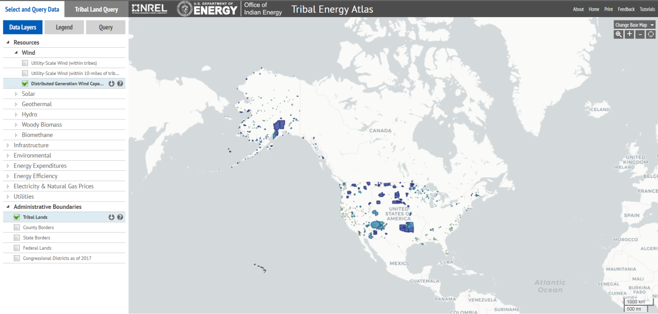
Screenshot of the user-friendly Tribal Energy Atlas tool.
We designed this tool to be highly intuitive, so no prior geospatial experience is needed to use it. It enables tribal energy planners, project managers, and technicians to view resource, infrastructure, and other relevant data about specific tribal lands, giving them direct access to the critical data sets they need to make informed decisions about their energy development options.
In addition to giving tribes unprecedented access to data, the tool also incorporates functionality that enables users to query the data by tribal land and conduct simple analyses of demographics, installed capacity, utility-scale renewable energy technical potential, and more. (Note that NREL is regularly updating data and adding newly federally recognized tribes, but there may be delays as data systems catch up with the recognition process.)
The tool includes built-in tutorials to assist users, as well as the ability to provide direct feedback on usability. For more information on the tool’s features and functionality, access the final webinar in the 2017 Office of Indian Energy webinar series, which provided a detailed tutorial on the tool in advance of its release.
What Is “Techno-economic Potential”?
Techno-economic potential combines two concepts: technical potential and economic potential. Technical potential represents the achievable energy generation of a particular technology given system performance, topographic limitations, environmental, and land-use constraints. The primary benefit of assessing technical potential is that it establishes an upper boundary estimate of energy development potential; however, it does not address any market limitations. Economic potential represents the subset of available energy generation that is economically viable in a specific area.
Behind the tool is a wealth of updated analysis on renewable energy potential on tribal lands. Specifically, “Techno-Economic Renewable Energy Potential on Tribal Lands,” recently released by NREL and funded by the Office of Indian Energy, documents the most current technical and economic tribal energy potential estimates included in the new Tribal Energy Atlas. This study updates, refines, and expands upon the information presented in the 2013 Office of Indian Energy report “Geospatial Analysis of Renewable Energy Technical Potential on Tribal Lands.”
The analysis behind the tool draws upon a variety of reliable sources, including resource assessment and technology models developed by NREL, the U.S. Census Bureau, the U.S. Geological Survey, the U.S. Department of Agriculture, and the Energy Information Administration. Inputs NREL used to perform the analysis include resource estimates, renewable energy cost and generation attributes, regional market electricity prices, and energy-support policies, among others. The resources analyzed include wind, solar photovoltaics (PV), concentrating solar power (CSP), woody biomass, biogas, geothermal, and hydropower.
Although the study focuses primarily on utility-scale renewable energy potential on tribal lands in the lower 48 states, it also highlights information on distributed-scale renewable energy technical and economic potential, which includes Alaska Native villages.
Fresh Insights Shine New Light on the Future of Tribal Energy
Key results from this techno-economic potential analysis include:
- While tribal lands make up approximately 5.8% of the land area in the conterminous United States, the estimated utility-scale renewable energy technical potential on these lands is 6.5% of the total national renewable energy technical potential.
- Solar PV is the top-ranking tribal utility-scale renewable energy resource, followed by CSP and wind, with relatively smaller contributions from other technologies.
- While distributed wind and PV potential exists to some degree for every tribal area, in low-resource areas they may not be cost-competitive with existing grid electricity prices.
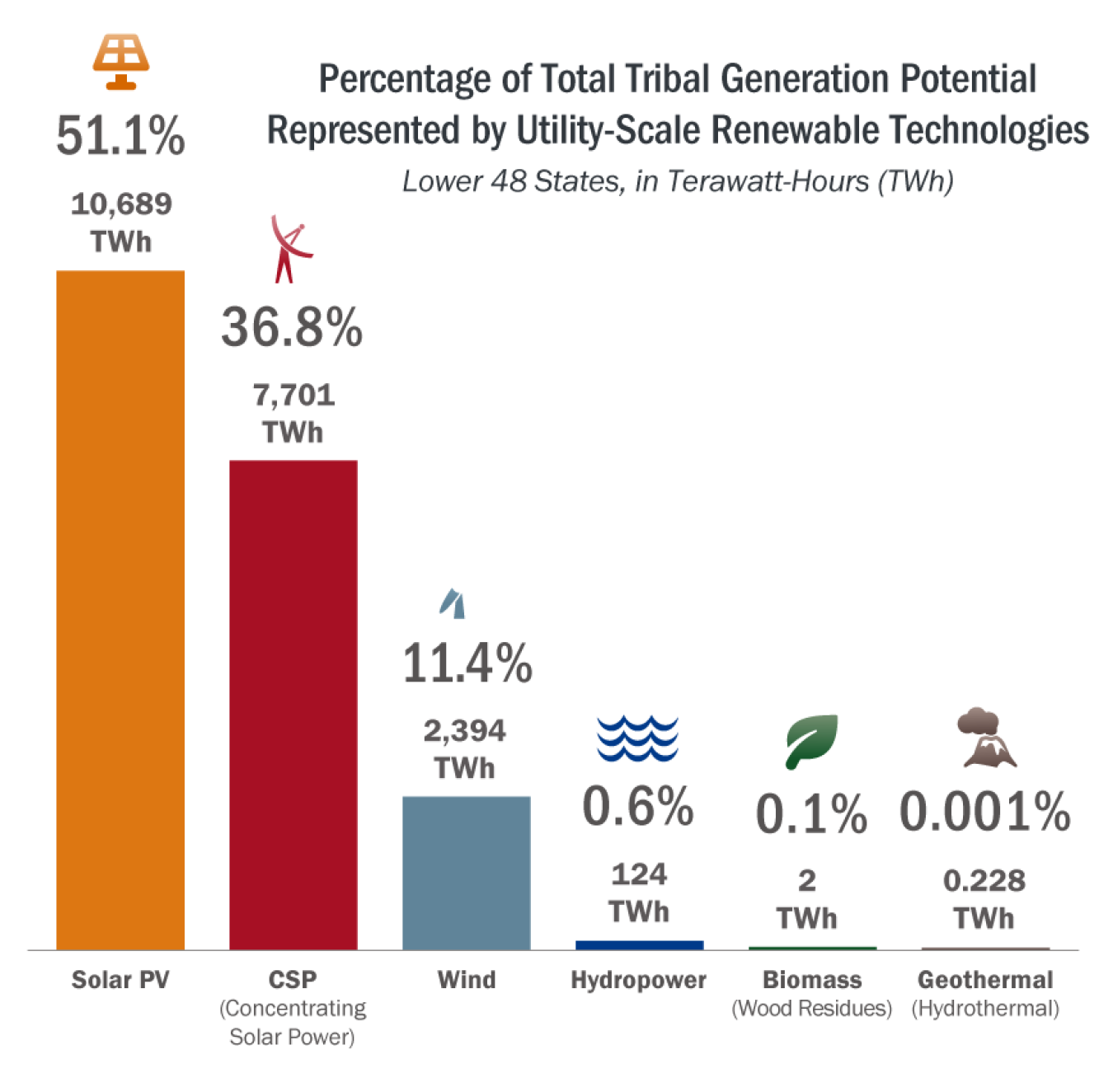
Solar resources account for nearly 90% of renewable energy generation potential on tribal lands in the conterminous 48 states.
Learn More
For more information on the techno-economic resource potential on tribal lands, download the report, and to evaluate the potential on your land, visit the Tribal Energy Atlas.