
EM has released a web-based mapping tool called TRAC, or Tracking Restoration And Closure, that transforms data and other technical material about groundwater plumes at EM sites into relevant, easy-to-understand information.
Office of Environmental Management
October 4, 2022WASHINGTON, D.C. – EM has released a web-based mapping tool called TRAC, or Tracking Restoration And Closure, that transforms data and other technical material about groundwater plumes at EM sites into relevant, easy-to-understand information.
Developed for EM by DOE’s Pacific Northwest National Laboratory, TRAC is focused on communicating cleanup status and technical challenges and needs for site closure at EM locations. The tool provides photographs, videos, summary narratives, geospatial visualization of groundwater plumes, and metrics about plumes, regulatory status and remediation technology implementation.
The TRAC application provides summary information on environmental restoration and progress toward closure at three levels of detail: EM complex, EM site and waste management unit. Each level includes corresponding information on history, cleanup challenges, remediation goals, conceptual site models, technology approaches, cleanup priorities and progress.
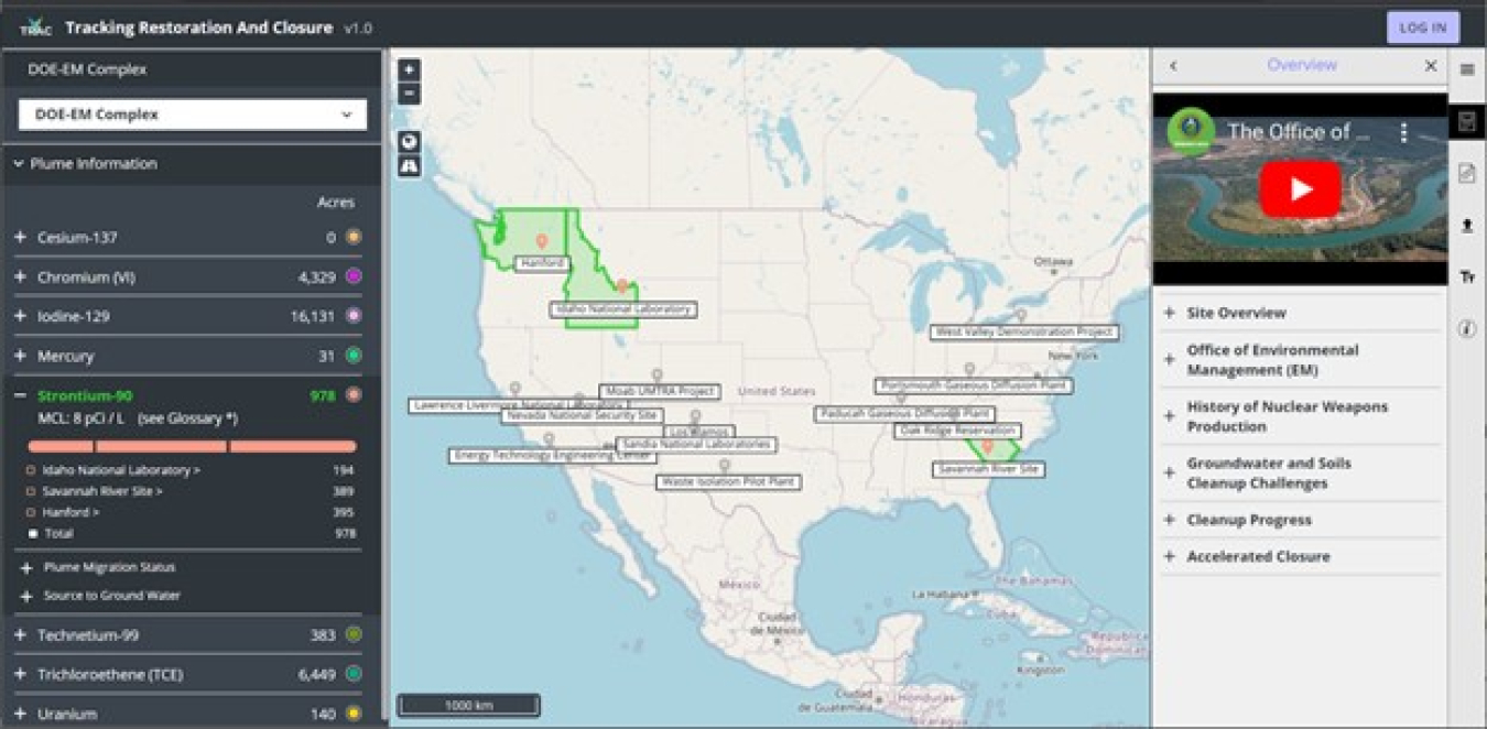
Metrics about contaminant plumes, regulatory context and status, and remediation technology approaches are defined for each contaminant at the waste management unit level. The metrics are compiled into totals at the EM site and EM complex-wide levels.
- The EM complex level focuses on high-priority contaminants of concern, displaying metrics and identifying sites with high-priority contaminant plumes.
- The EM site level provides a geospatial footprint of groundwater plumes and site-specific information and metrics on progress toward site closure.
- The waste management unit level provides detailed visualization of contoured groundwater concentrations and specific metrics on the status of groundwater cleanup.
- Plume metrics include a geospatial depiction of the plume on the map, area of the plume footprint and status of plume migration and the contaminant source.
- The regulatory metrics include identification of the controlling regulatory framework, the regulatory stage and status, and associated regulatory documents.
- Technology information describes the technologies applied, implementation status and specific technology metrics, such as mass removed.
Unlike the data access tools maintained at some EM sites, TRAC is not a portal for data downloads, nor is it a tool for performing data analytics. Rather, the goal of TRAC is to provide relevant information on cleanup progress and closure consistent across all sites, allowing the user to view summary information or examine information relevant to a particular site.
That information sharing is needed to develop and track a complex-wide groundwater closure strategy, maintain open communications with interested parties and communicate efforts that ensure long-term protection of human health and the environment.
TRAC also is an online information resource that promotes the sharing of technologies, successes and lessons learned across the EM complex by providing a single, consistent framework for integrating and standardizing information among EM sites.
TRAC, jointly funded by EM's Technology Development Program and the EM Office of Subsurface Closure, currently includes data from the Hanford, Idaho National Laboratory and Savannah River sites but is set to be updated soon to include groundwater data from across the entire complex.
For more information about TRAC or to login and start exploring the application, click here.
To receive the latest news and updates about the Office of Environmental Management, submit your e-mail address.