
A comprehensive, regularly updated data set of U.S. wind turbine locations and characteristics is now publicly available.
Integrated Energy Systems Office
May 8, 2018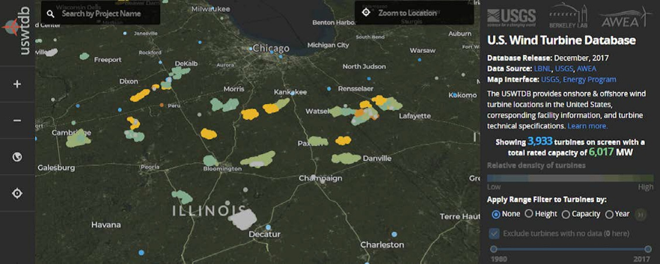
The United States Wind Turbine Database contains nearly 60,000 turbines in more than 1,700 wind power projects spanning 43 states, Puerto Rico, and Guam. Database screen capture by Ben Hoen, Lawrence Berkeley National Laboratory
A comprehensive, regularly updated data set of U.S. wind turbine locations and characteristics is now publicly available. The United States Wind Turbine Database (USWTDB) currently contains nearly 60,000 turbines, constructed from the 1980s through 2018, in more than 1,700 wind power projects spanning 43 states plus Puerto Rico and Guam. The data set details turbines smaller than 30 meters, with capacities less than 70 kilowatts, to turbines towering 181 meters (593 feet), with capacities of 6 megawatts. The data cover not only land-based turbines, but also offshore installations.
The USWTDB was developed in 2017 with U.S. Department of Energy support under a partnership among Lawrence Berkeley National Laboratory, the United States Geological Survey, and the American Wind Energy Association. This joint product is more comprehensive, accurate, and regularly updated than each individual organization's proprietary wind turbine data sets.
Since early 2017, the USWTDB has been used by the Departments of Defense and Homeland Security and the National Oceanic and Atmospheric Administration to perform crucial operational impact assessments of turbines on radar.
"The USWTDB directly supports the North American Aerospace Defense Command's air defense mission by enabling us to conduct credible and meaningful analysis of wind turbine-radar interference impacts and ultimately helps ensure that U.S. renewable energy does not adversely impact our ability to conduct our homeland defense mission," said Major-General Christopher Coates, North American Aerospace Defense Command director of operations.
Now, these same data can be accessed by researchers and the public via an online portal: the USWTDB Viewer.
Examples include studying wind energy-wildlife interactions, reviewing economic impact assessments of wind energy's deployment, examining the role of wind energy in the U.S. electric grid, predicting future deployment patterns, and better understanding wind deployment in one's local geography.
The data set includes not just the location of the turbines, but characteristics of each turbine, such as the make and model, total height, hub height, rotor diameter, the year of installation, and rated capacity to produce electricity.
This public-private partnership has allowed the individual organizations to combine their large proprietary turbine data sets with those of the Federal Aviation Administration. Many of these data have been vetted numerous times by multiple institutions and, therefore, are already of high quality in addition to the comprehensive quality control to ensure the data are as accurate as possible.
The USWTDB Viewer, the development of which was led by the United States Geological Survey Eastern Energy Resources Science Center, is unprecedented in its ability to search and sort the U.S. wind turbine fleet. Users can interact with the data using multiple filters and colorings to allow wind projects across counties, states, or regions to be quickly scanned for unique qualities. The full data set can be downloaded in a variety of formats, and users can connect to the underlying data via web services incorporating the Viewer into their own website.