
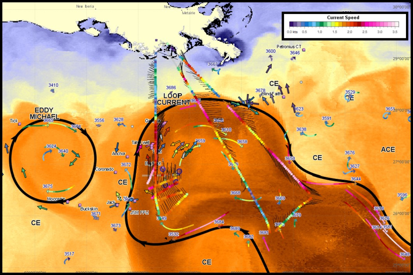
Ocean surface current velocities on image of sea surface temperatures, March 29, 2015. Figure from “Real Time Observing and Forecasting of Loop Currents in 2015,” C. Cooper et al, OTC 2016.
In a breakthrough project sponsored by the Energy Department’s National Energy Technology Laboratory (NETL), private-sector partners Fugro and Areté Associates have developed, commercialized, and sold a system that can monitor offshore current conditions from the air, providing critical information in record time for oceanographic research and emergency situations, such as oil spills and search and rescue missions.
The new technology, called the Remote Ocean Current Imaging System (ROCIS), measures ocean surface current velocities from an airplane in near real-time over a broad area. The system was recently deployed on its first operational project to characterize conditions in the U.S. Gulf of Mexico during a period of intense current conditions over a distance of more than 78,000 statute miles—the equivalent of about three trips around the world.
ROCIS is the first commercially available system of its kind and represents a significant advancement in technology for mapping surface current conditions over a wide area of ocean. In just four hours, the system can survey ocean currents at 800-foot intervals over a track of 500–680 miles. Traditional methods would take a combination of four vessels 24 hours to cover the same area.
Optimizing recent advances in remote sensing and aerial survey, Fugro and Areté Associates developed ROCIS using digital camera technology, highly accurate positioning systems, and advanced image processing algorithms to derive surface currents from wave measurements. The technology can be installed on survey aircraft equipped with a navigation system augmented by Fugro’s Starfix© satellite positioning system.
Using ROCIS, data is reviewed in real time on board the aircraft. Within an hour after the aircraft lands, the system produces a “quick-look” map of the currents over the surveyed area. Processed data files are available a few hours later.
Funding for the project was provided through the Ultra-Deepwater and Unconventional Natural Gas and Other Petroleum Resources Research and Development Program authorized by the Energy Policy Act of 2005. The program, funded from lease bonuses and royalties paid by industry to produce oil and gas on federal lands, is designed to assess and mitigate risk, enhancing the environmental sustainability of oil and gas exploration and production.
NETL contracted the nonprofit Research Partnership to Secure Energy for America (RPSEA) to administer funding for the program. The consortium has more than 120 members, including 17 premier research universities, 5 national laboratories and major research institutions, large and small energy producers, and energy consumers. RPSEA, headquartered in Sugar Land, Texas, helps to provide focused research, development, and deployment of safe and environmentally responsible technologies that can deliver hydrocarbons from domestic resources.